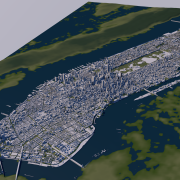
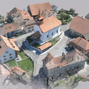
DEM Earth update to 4.493 available.
Getting ready for R25 !
This build is available via prefs if you already have version 4.490 or greater.
- 4.493 Aug 14th 2021
DEM Earth – loading and refresh issues resolved. - 4.491 Aug 3rd 2021
DEM Earth prefs – Additional information for license type and clearer explanations of what might be wrong if you fail to connect.
DEM Earth prefs – Download updates directly from prefs.
DEM Earth License – If there is a server problem or you lose your internet connection, the plugin will continue to work for up to 10 days without a connection to the DEM Earth license server.
DEM Earth Cloner – Faster. Various bugfixes and threading improvements. Works much better with larger areas.
DEM Earth – Improved background loading response.
DEM Earth – Faster Sampling code makes everything even better!
DEM Earth Interpolation – improvements Various bug fixes.
DEM Earth PinPoint – Placement bug fix.
DEM Earth Geocoder – bug preventing pinpoints from being built – fixed.
Black Friday Days
Save 20%
Us the code “CinemaPluginsBlackFriday” in the cart.
From Nov 26th to Nov 30th 2019 on all plugins and services at cinemaplugins.com

Maxon 2015 Roadshow Sponsorship
Cinema4D Hits The Road – 8 cities, 9 weeks, food, drinks, prizes, C4D mastery
- Learn how to easily create dazzling motion graphics – even if you’re a beginner.
- Discover tricks used by world-class 3D creatives.
- Win from thousands of dollars worth of prizes.
- Free food and drinks.
- Hang out with amazing people from the C4D community.
CinemaPlugins.com is proud to be a major sponsor for this event.
To celebrate, we are offering a 15% discount on all of our plugins and services, for the duration of the roadshow. Use the code ‘MaxonRoadshow2015′ in the cart for a great discount.